Sonar Technology: From Detecting Submarines to Guiding Marine Management Decisions
July 31, 2012
By Mera McGrew
Originally invented during World War I to detect submarines, today oceanographers and other marine professionals are using sonar technology to advance knowledge of the world’s ocean.
Specifically, sonars can help map out crucial marine habitats. But, that is just a start. In the future, some researchers suggest that information generated through sonar technology could influence how marine habitats are regulated and even managed.
Last week, one research group boarded the Nancy Foster, a National Oceanic and Atmospheric Administration ship on a 10-day cruise, to conduct sonar-based experiments aimed at better understanding fish spawning and fish movement in and around the Florida Keys National Marine Sanctuary’s Tortugas Ecological Reserve, located 70-miles west of Key West.
The research cruise falls in the middle of a multi-year Florida Keys National Marine Sanctuary zoning review that seeks to determine whether the current sanctuary boundaries adequately protect marine habitats and resources.
The cruise’s Chief Scientist, Dr. Scott Donahue, who is also the Florida Keys National Marine Sanctuary’s Science Coordinator, told Mission Blue that over the 10-day mission scientists, “will be looking closely at habitat and bathometric characteristics and how they relate to the fish aggregations and spawning sites…”
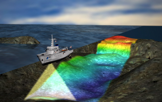
To map out these various habitats, Donahue and his research team will deploy state-of-the-art sonars that much like traditional sonars, project energy and analyze the return signal or echo of the energy that has bounced off the sea floor or submerged object.
Specifically, researchers will use a multibeam sonar system, which works by beaming out a set of fan-shaped sounds into the water from a device placed directly beneath the ship’s hull. The projected sound bounces off the targeted area at different rates and angles. All the sound signals are then processed by computers and converted into a detailed three-dimensional map of the sea floor.
To collect information about fish aggregations, the research team will also use a split-beam sonar. Similar to conventional sonar technology, once the split-beam sonar is submerged in the water it emits a beam of sound waves, when the sound waves encounter an object with a density different than water, such as a fish’s swim bladder, some of the sound waves bounce back to the ship. Researchers told Mission Blue that they would use the split-beam sonar in conjunction with remote operated vehicles and traditional SCUBA to confirm specific spawning aggregations in addition to measuring the size of the aggregation and the fish themselves in some key habitats identified in advance within the Tortugas Ecological Reserve.
The sonar technology onboard the Nancy Foster is bound to generate accurate surveys of the ocean’s floor and fish spawning aggregations while also offering researchers added reassurance as to the accuracy and quality of any and all data they collect. (Researchers point out that the use of sonar technology can help to overcome some of the limitations and sampling biases associated with traditional trawling surveys.)
The role that sonar will play in the future of science and marine management is not fully known. However, the current Nancy Foster cruise is positioned to offer insight into the potential role it could have as data is referenced and taken into consideration during the current multi-year Florida Keys National Marine Sanctuary zoning review. For now, the Florida Keys National Marine Sanctuary superintendent Sean Morton has said, “the scientific results of this cruise will help inform the public and guide management decisions as we continue to look at sanctuary marine zones and regulations.”
Top photo: NOAA