December 16, 2013
We’re honored today to deliver you the results of Mission Blue Partner KAI Marine Service‘s Project OASIS, which studied loggerhead turtles in the Mediterranean. Enjoy!
=-=-=
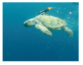
Over 4 months of survey in the Mediterranean open sea, tracking and observing loggerhead sea turtles in their oceanic stage has enabled research to gain new insight of how this ecosystem functions. A total of 118 turtles have been part of the OASIS project in its first edition. Equipped with National Geographic Crittercam, satellite tags and acoustic tags, turtles have become “living oceanographic gliders” recording data that should hopefully allow scientists to reveal the mystery of the “Mediterranean Serengeti Paradox”.
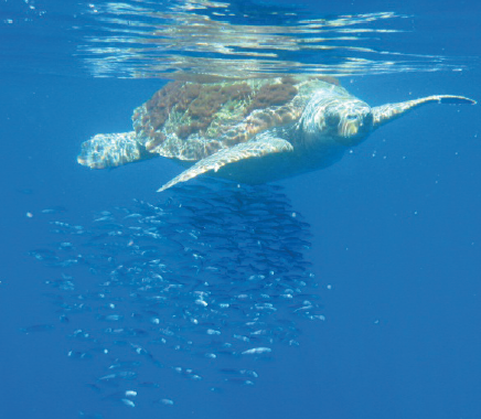
Each loggerhead turtle basking on the surface during its oceanic phase becomes an oasis that aggregates algae and invertebrates, ultimately aggregating a bait ball for top predators in the open ocean realm to feed on.
WHY OASIS? – The open seas ecosystem still retains many exciting mysteries for scientists. Vast nutrient poor regions of crystal clear deep blue waters that would compare on land with deserts as the Serengeti, sustain a large biomass of top predators as cetaceans, sharks, and tunas. In these marine desserts, the oasis of food aggregation can be any drifting object as algae, logs or unfortunately in modern times also debris.
Juvenile and sub adult loggerhead turtles in the first years of their lives have an oceanic stage during which they migrate passively with the currents. Understanding their habitat use in this stage is a top priority in the context of their conservation, given the high toll threats as byctach in fisheries, vessel strikes or debris pollution take on thriving turtle populations.
The OASIS project looks at this habitat use but also takes the opportunity of spending many hours in this open sea environment to try elucidate some of the questions we pose ourselves on how it functions. Modern technologies of satellites, digital telecommunications and oceanographic robots as gliders and buoys have revolutionized oceanography over the last decades giving us oceanographic monitoring and forecasting platforms as MYOCEAN or SOCIB. However a necessary step to calibrate these tools and understand the oceans at a fine scale, requires a closer look at what is happening on site. In the Pacific Ocean, Dr. B. Block’s team at the Hopkins Marine Station has made much progress at this level through projects as TOPP and Tag a Giant. This fabulous work has solved many questions, but has also opened new ones as that of the famous “White Shark Café”, a hotspot of shark aggregation that puzzles the minds of marine biologists, and that is probably the most visual way to relay to the general public the fascinating stage we are at in starting to understand our deep blue Serengeti’s.
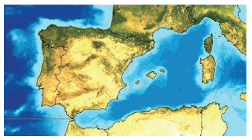
The SW Mediterranean is one of these Serengeti’s. It is the breeding site of the main Atlantic stock of Bluefin tuna but also foraging ground of many other predators as sharks, swordfish, cetaceans and sea turtles. But the Mediterranean is also a small semi enclosed sea, and this makes it the perfect oceanographic laboratory where we can intensify the cost efficiency of science to tackle some of our questions with regards to how the open seas work.
And this is why, in the context of the OASIS project this unique hotspot of biodiversity, has become “white shark café” for aggregating scientists from Alnitak, Stanford University, National Geographic, HYDRA Institute the Spanish Oceanographic Institute (I.E.O.), the IMEDEA SOCIB, Sea Turtle Network of France (GTMF), Siena University and KAI Marine Services.
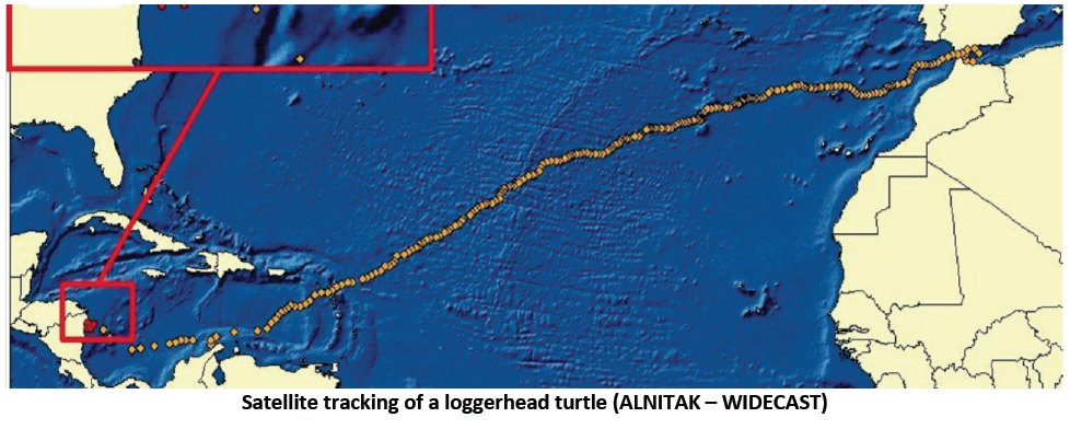
OASIS I has worked in open waters and four NATURA 2000 sites developed for the conservation of the loggerhead turtle and the bottlenose dolphin in the framework of the European Union Habitat Directive; the Strait of Gibraltar, the Island of Alboran, the Mazarron Escarpment and the Channel of Menorca. These sites are of particular relevance to sub adult turtles that after several years using the SW Mediterranean as a foraging habitat during their oceanic stage, switch to their neritic stage feeding on high nutritious value crustaceans to prepare for a transoceanic voyage to their breeding habitat along the shores of the Caribbean and East Coast of the US.
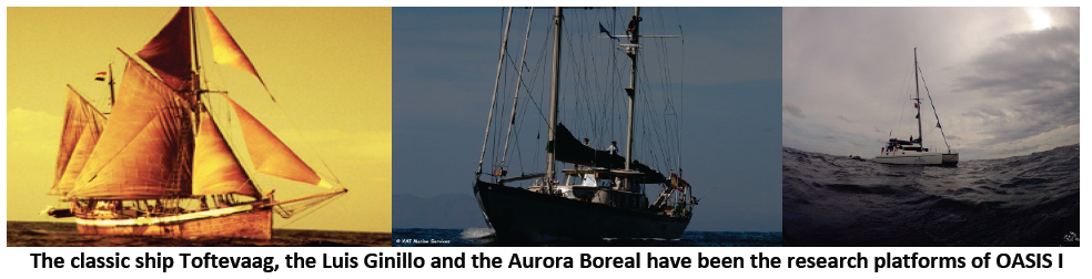
ENTERING THE OPEN OCEAN DOMAIN AND BECOMING A PART OF IT – Three sailing vessels have spent over 4 months at sea combining visual and acoustic surveying with what we now refer to as “oasis experiments”, where we gently and quietly enter the water to become part of the open seas and observe the turtles as one would observe a wild animal on land.
In OASIS I we have been looking at developing experimental set ups to study habitat use and behavioural response of basking turtles. Divers with cameras have spent over 50 hours in the water obtaining an equal amount of hours of video on basking behaviour of turtles.
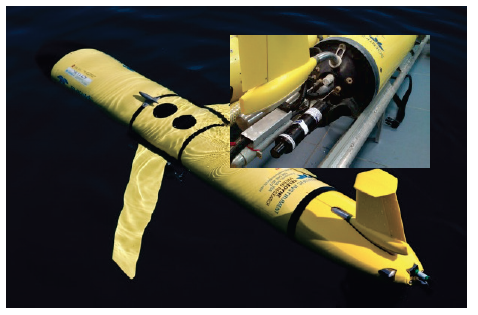
The results of these studies will serve to calibrate the “OASIS buoy”, one of the main products of this project. Developed by the research team of HYDRA Institute, this buoy equipped with biomass sensors and cameras will be used in OASIS I to conduct further experiments that should provide us with information that can be useful to mitigate the threats turtles face in the open ocean.
For turtles in the neritic stage, and with regards mainly to the risks of bycatch in gill nets and poundnets, HYDRA has designed another tool, an experimental lobster trap that equipped with cameras looks in detail at the sea floor habitat that turtles use before their Atlantic crossing.
INTERACTIONS WITH FISHERIES – Bycatch in fisheries is a major threat for pelagic sea turtles as the loggerhead or leatherback turtles. To solve these problems, working in cooperation with fishermen is essential. In the SW Mediterranean, Alnitak has worked with the Spanish longlining fleet since 1986 obtaining very encouraging results in a fishery that until recently had extremely high bycatch rates. Fishermen now are adapting measures as deep fishing and changing bait to reduce bycatch. Every year, scientists and fishermen get together to discuss progress in bycatch mitigation science and also improved sea turtle handling and release methods.
Now, in the OASIS project we are looking at other fisheries where bycatch is less conspicuous than in longlining, but nevertheless a risk that requires assessment and monitoring. Fortunately the success story of the longlining fishery provides us now with a good head start to convince fishermen that through collaboration we can work towards win-win solutions.
Understanding diving patterns of sea turtles and also target species of the fisheries has been one of the key factors for reducing the risk of bycatch and reducing turtle mortality.
Relating maps from oceanographic platforms as MYOCEAN or SOCIB to the aggregation of turtles in order to develop tools for bycatch risk zoning is another objective of Alnitak since it started using satellite tags to track turtle movements. At present, under the “Service to Fishermen” website, Alnitak offers an experimental tool that is still far from perfect, so one of the challenges now is to convince fishermen that through their collaboration and bycatch reporting this tool could one day have enough data to be a tool as useful for them as the modern weather forecasts.
SEA TURTLES AS LIVING GLIDERS – Until the OASIS project, the relation between the turtles and oceanographic platforms was only one way, with satellite information on sea surface temperature, chlorophyll, height and currents being used by Alnitak to analyse turtle movements and habitat use. Now in OASIS I, it has become a “give & take” with turtles contributing to oceanographic monitoring platforms with the data they collect through the satellite tags. It’s a little bit as if the turtles had become natural gliders.
Another innovation of the OASIS project in the Mediterranean has been the introduction of new types of tags to complement the information of satellite transmitter. In April, Greg Marshall and Kyler Abernathy joined the crew on board the Luis Ginillo to conduct some first trials of turtle tracking with National Geographic Crittercam.
During the OASIS survey on board the research vessel Toftevaag, a juvenile North Atlantic loggerhead turtle was tagged with an acoustic transmitter that should provide information of its movements for approximately 6 years. This acoustic tagging, conducted with Barbara Block’s team also included the tagging of 8 bluefin tunas caught in the poundnets of Larrache at the Strait of Gibraltar — http://tagagiant.blogspot.com/.
Passive acoustic monitoring is likely to be one of the main tools for monitoring the populations of great pelagics, but this will require several years of intensive tagging and also the development of an appropriate infrastructure for listening and detecting the ultrasonic “beeps” of the tagged turtles, whales, sharks and tuna. In the Mediterranean, OTN (http://oceantrackingnetwork.org) is currently finishing the construction of a chain of receivers across the Strait of Gibraltar, an important first step towards this monitoring tool of the future. In OASIS I, through collaboration with J. Tintore’s team of SOCIB ( www.socib.es) a first test was conducted to attach one of these acoustic tag detectors of Vemco on one of the gliders they use to monitor the Balearic Sea and more specifically the Channel of Ibiza.
Although the amount of data collected from the OASIS I surveys and tracking devices has been outstanding and has allowed to obtain very interesting new knowledge for finding solutions to the risks for sea turtle populations in coastal NATURA 2000 sites and the open seas, the main aim of this first edition was to design experimental set ups and take the first steps for the establishment of an ambitious global Mediterranean monitoring for pelagic species. The preliminary results of the work conducted during these four months at sea have been presented today in Madrid at the National Geographic Café by Alnitak and the Fundacion Biodiversidad of the Spanish Ministry of Agriculture, Food and Environment, in a “come together” of scientists, policy makers, fishermen and the general public.
ELLA MAILLARD’s BLOG – Explaining to the public that the apparently empty blue surface of the sea in fact hides an amazing world of creatures is especially important in the Mediterranean, where most people only see as far as the beach and the bar. The closest they get to feel the reality of the marine environment is when the jelly fish of the open seas get close to their beaches. In the OASIS I project outreach has been primarily through Internet communication platforms as Mission Blue of Sylvia Earle, where through Google Ocean there are now 15 posts, curate by Charlotte Vic’s team, that introduce the public to the project and its site. Through Alnitak’s website of the project, which includes the “Service to Fishermen” and information on the uniqueness of the biodiversity hot spot of the SW Mediterranean, a blog of the tracking of a satellite tagged turtle tries to introduce the public to the exciting world of satellite telemetry. In this blog, the tagged turtle receives the name of one of the great adventurers of the 20th Century, Ella Maillard (www.alnitak.info).
